Burma B&W – Part 1

© RicardMN Photography

B&W photographs of Burma by RicardMN Photography.
http://ricardmn-photography.pixels.com/
Music: Silk Road – Kitaro.

Myanmar, officially the Republic of the Union of Myanmar and formerly known as Burma, is a sovereign state in Southeast Asia. Myanmar is bordered by India and Bangladesh to its west, Thailand and Laos to its east and People’s Republic of China to its north and northeast. To its south, about one third of Myanmar’s total perimeter of 5,876 km (3,651 mi) forms an uninterrupted coastline of 1,930 km (1,200 mi) along the Bay of Bengal and the Andaman Sea. The country’s 2014 census counted the population to be 51 million people. As of 2017, the population is about 54 million. Myanmar is 676,578 square kilometers (261,228 square miles) in size. Its capital city is Naypyidaw, and its largest city and former capital is Yangon (Rangoon).

Early civilisations in Myanmar included the Tibeto-Burman-speaking Pyu city-states in Upper Burma and the Mon kingdoms in Lower Burma. In the 9th century, the Bamar people entered the upper Irrawaddy valley and, following the establishment of the Pagan Kingdom in the 1050s, the Burmese  language, culture and Theravada Buddhism slowly became dominant in the country. The Pagan Kingdom fell due to the Mongol invasions and several warring states emerged. In the 16th century, reunified by the Taungoo Dynasty, the country was for a brief period the largest empire in the history of Mainland Southeast Asia. The early 19th century Konbaung Dynasty ruled over an area that included modern Myanmar and briefly controlled Manipur and Assam as well. The British took over the administration of Myanmar after three Anglo-Burmese Wars in the 19th century and the country became a British colony. Myanmar was granted independence in 1948, as a democratic nation. Following a coup d’état in 1962, it became a military dictatorship.

For most of its independent years, the country has been engrossed in rampant ethnic strife and its myriad ethnic groups have been involved in one of the world’s longest-running ongoing civil wars. During this time, the United Nations and several other organisations have reported consistent and systematic human rights violations in the country. In 2011, the military junta was officially dissolved following a 2010 general election, and a nominally civilian government was installed. This, along with the release of Aung San Suu Kyi and political prisoners, has improved the country’s human rights record and foreign relations, and has led to the easing of trade and other economic sanctions. There is, however, continuing criticism of the government’s treatment of ethnic minorities, its response to the ethnic insurgency, and religious clashes.  In the landmark 2015 election, Aung San Suu Kyi’s party won a majority in both houses. However, the Burmese military remains a powerful force in politics. (From Wikipedia).

Canvas, framed, acrylic and metal prints / Art prints / Greeting cards / Phone cases / Throw pillows

RicardMN Photograpy’s Facebook PageRicardMN Photography’s Pinterest

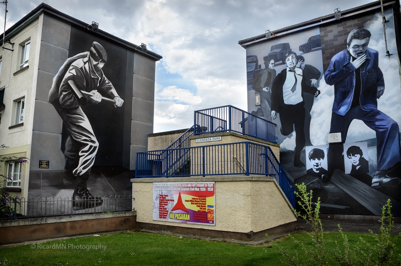
Operation Motorman mural in Derry

© RicardMN Photography

© RicardMN Photography

Mural painted by ‘the Bogside Artists’. The mural was completed in July 2001 and is situated on Rossville Street in the Bogside area of Derry, Northern Ireland, United Kingdom. The mural depicts some of the events that occured during ‘Operation Motorman’ on 31 July 1972.

The Bogside Artists are a trio of mural painters from Derry, Northern Ireland, consisting of Tom Kelly, his brother William Kelly, and Kevin Hasson (b. 8 January 1958). Their most famous work, a series of outdoor murals called the People’s Gallery, is located in the Bogside neighbourhood of Derry and depicts the events surrounding sectarian violence and civil rights protests in Northern Ireland during the Troubles.

Operation Motorman was a large operation carried out by the British Army (HQ Northern Ireland) in Northern Ireland during the Troubles. The operation took place in the early hours of 31 July 1972 with the aim of retaking the “no-go areas” (areas controlled by residents, usually Irish republican paramilitaries) that had been established in Belfast, Derry and other large towns. During the operation, the British Army shot four people in Derry, killing a civilian and an unarmed IRA member.

The Bogside is a neighbourhood outside the city walls of Derry, County Londonderry, Northern Ireland. The large gable-wall murals by the Bogside Artists, Free Derry Corner and the Gasyard Féile (an annual music and arts festival held in a former gasyard) are popular tourist attractions. The Bogside is a majority Catholic/Irish republican area, and shares a border with the Protestant/Ulster loyalist enclave of the Fountain.

The area has been a focus point for many of the events of the Troubles; in 1969, a fierce three-day battle against the RUC and local Protestants, known as the Battle of the Bogside, became a starting point of the Troubles.

Between 1969 and 1972, the area along with the Creggan and other Catholic areas became a no-go area for the British Army and police. Both the Official and Provisional IRA openly patrolled the area and local residents often paid subscriptions to both.

On the 30 January 1972, the Northern Ireland Civil Rights Association organised a march against internment that was put into effect the year before turned into a blood bath known as Bloody Sunday. The British Parachute Regiment shot dead 14 unarmed protesters and injured 14 more; this resulted in a large surge of recruitment for both wings of the IRA in the city.

After Operation Motorman and the end of Free Derry and other no-go areas in Northern Ireland, the Bogside along with the majority of the city experienced frequent street riots and sectarian conflict lasting all the way to the early 1990s.

In 1974, the Official IRA declared an end to their armed campaign, and with volunteers on the ground already mad about the ceasefire in mid 1972, that crossed the line to hardliners. In result, Seamus Costello and other socialist militants formed the Irish Republican Socialist Movement. This new movement included the Irish National Liberation Army the paramilitary wing of the IRSM.

Derry and particularly the Bogside became one of many strongholds for the INLA; in fact all three volunteers who died in the 1981 Irish hunger strike were from Derry or County Londonderry. The Irish People’s Liberation Organisation, a breakaway group of the INLA, made a small but effective presence in Derry engaged in a feud with the INLA in the city along with other areas in Ireland from 1987 to 1992. The feud ended with the Provisionals stepping in and killing the main Belfast leadership while letting the rest of the organisation dissolve in the rest of Ireland. Throughout the rest of the 1990s, the Bogside became relatively peaceful compared to other localities of Northern Ireland at that time such as Belfast, even though street riots were still frequent. (Description from Wikipedia)

Canvas, framed, acrylic and metal prints / Art prints / Greeting cards / Phone cases / Throw pillows

RicardMN Photograpy’s Facebook PageRicardMN Photography’s Pinterest

bogside metal prints for salebogside prints for sale

Our Lady Chapel detail in the Ons’ Lieve Heer op Solder Amsterdan BW

© RicardMN Photography

© RicardMN Photography

Our Lady chapel detail in the Ons’ Lieve Heer op Solder (Our Lord in the Attic), a 17th-century canal house in the city center of Amsterdam, The Netherlands.

The canal house on the 14th century canal Oudezijds Voorburgwal, currently on number 40, was built in 1630. Between 1661 and 1663 the top three floors of the house were changed into a house church. The building was renovated in the 18th and 19th century.

The Catholic Church was built on the top three floors of the canal house during the 1660s. It is an important example of a “schuilkerk”, or “clandestine church” in which Catholics and other religious dissenters from the seventeenth century Dutch Reformed Church, unable to worship in public, held services.

Since there is no room for an altar to Mary in the Attic Church, the area behind the main altar has been set up as a chapel to Our Lady. Immediately alongside the altar, there is a multi-coloured limewood statue of Maria (circa 1690) thought to originate from the Attic Church. She carries Jesus under her arm and is standing on the crescent moon. She has a snake caught under her feet, a symbol of all evil.

Canvas, framed, acrylic and metal prints / Art prints / Greeting cards / Phone cases / Throw pillows

RicardMN Photograpy’s Facebook PageRicardMN Photography’s Pinterest

amsterdam prints for sale

The Dunbrody Crew’s Kitchen

© RicardMN Photography

© RicardMN Photography

Canvas, framed, acrylic and metal prints / Art prints / Greeting cards / Phone cases / Throw pillows

RicardMN Photograpy’s Facebook PageRicardMN Photography’s Pinterest

The Dunbrody Crew’s Kitchen. New Ross, County Wexford, Ireland.

The Dunbrody was a three-masted barque built in Quebec in 1845 by Thomas Hamilton Oliver for the Graves family, merchants from New Ross in Wexford.

She operated primarily as a cargo vessel, carrying timber and guano to Ireland.

She was fitted with bunks and between April to September from 1845 to 1851, she carried passengers on the outward leg to North America. These passengers were people desperate to escape the potato famine in Ireland at the time and conditions for steerage passengers were tough.

An area of 6 foot square was allocated to up to 4 passengers (who might not be related) and their children. Often 50% died on passage (they were known as “coffin ships”). However, the mortality rate on the Dunbrody was exceptionally low, no doubt due to her captains, John Baldwin and his successor John W. Williams, with passengers writing home often praising their dedication. On one passage with 313 passengers, almost twice her normal complement, only 6 died.

In 1869, after 24 years of service with the Graves family, she was sold. In 1874, while travelling from Cardiff to Quebec, she ran aground in the Saint Lawrence River. She was bought by a salvage company, repaired and sold again but in 1875 she foundered on the Labrador coast and was lost.

Since May 2001 the replica Dunbrody has been open to visitors at the quayside in New Ross. Visitors can see an interactive exhibition and experience life on board an emigrant ship.

Ramesses II In Battle

© RicardMN Photography

© RicardMN Photography

Wall Painting of Temple of Beit El-Wali, which Ramses II constructed in Nubia during a period of the New Kingdom (1550 B.C. to 1069 B.C.) when the ancient Egyptians controlled the area. This Plaster Cast is in the British Museum, London, United Kingdom.
The Beit el-Wali temple is located in the area south of Egypt known to the Egyptians as Wawat, and to us as ancient ‘Nubia’. It supposed to remind the local people of the power of the Egyptian pharaoh, and to promote the worship of Egyptian gods.
There is a courtyard, decorated with scenes showing the pharaoh Ramesses II in battle against the enemies of Egypt. The southern wall of the courtyard has reliefs showing a battle between the Egyptians and their enemies to the south, the Nubians.
The plaster cast of the wall reliefs from the Beit el-Wali temple is on display in the ‘Egypt and Africa’ room (Room 65) of the British Museum in London.

Canvas, framed, acrylic and metal prints / Art prints / Greeting cards / Phone cases / Throw pillows

RicardMN Photograpy’s Facebook PageRicardMN Photography’s Pinterest

King Charles I observing Glamis Castle in Scotland

© RicardMN Photography

© RicardMN Photography

Monument of King Charles I in front of Glamis Castle, Scotland.

Glamis Castle is situated beside the village of Glamis in Angus, Scotland. It is the home of the Earl and Countess of Strathmore and Kinghorne.
Glamis Castle has been the home of the Lyon family since the 14th century, though the present building dates largely from the 17th century. Glamis was the childhood home of Elizabeth Bowes-Lyon, who married King George VI, and was later known as Queen Elizabeth The Queen Mother. Her second daughter, Princess Margaret, was born there.
The castle is protected as a category A listed building, and the grounds are included on the Inventory of Gardens and Designed Landscapes in Scotland, the national listing of significant gardens.

Charles I was monarch of the three kingdoms of England, Scotland, and Ireland from 27 March 1625 until his execution in 1649.
Charles was the second son of King James VI of Scotland, but after his father inherited the English throne in 1603, he moved to England, where he spent much of the rest of his life. He became heir apparent to the English, Irish and Scottish thrones on the death of his elder brother in 1612. An unsuccessful and unpopular attempt to marry him to a Spanish Habsburg princess culminated in an eight-month visit to Spain in 1623 that demonstrated the futility of the marriage negotiations. Two years later he married the Bourbon princess Henrietta Maria of France instead.

Prints/greeting cards/phone cases – RicardMN Photograpy’s Facebook Page – RicardMN Photography’s  Pinterest

The Bridge Of Mantible

© RicardMN Photography© RicardMN Photography

The Bridge of Mantible (Spanish: Puente Romano de Mantible) is a ruined bridge located near Logroño, Spain. It crosses the Ebro river to connect El Cortijo and Assa.
According to some historians, construction of the bridge began in the first half of the 2nd century, well into Rome’s imperial period. Others suggest that the bridge was built in the 11th century, near the same time in which the Puente La Reina was constructed over the River Arga, and that both were made to join the two most important cities of the Kingdom of Navarre, Nájera and Pamplona.
Neither theory makes clear at what point the bridge became no longer passable, but there are documents that suggest that it had already fully deteriorated by halfway through the 16th century.
The bridge is 164 meters long, 5 meters wide and reaches a maximum height of 30 meters. It was built with seven semicircular arches, only two of which stand relatively intact today. There are only a few remains of the other five arches. The two standing arches serve as an example of the excellent quarry stone used in the bridge.
It was declared Bien de Interés Cultural in 1983.

Prints/greeting cards/iPhone cases – RicardMN Photograpy’s Facebook Page – RicardMN Photography’s  Pinterest
roman photos

Old House In Culloden Battlefield

© RicardMN Photography

© RicardMN Photography

Thatched roofed farmhouse of Leanach in Culloden battlefield, Scotland, UK.

Culloden is the name of a village three miles east of Inverness, Scotland and the surrounding area. Three miles south of the village is Drummossie Moor, site of the Battle of Culloden.
The Battle of Culloden was the final confrontation of the 1745 Jacobite Rising. On 16 April 1746, the Jacobite forces of Charles Edward Stuart fought loyalist troops commanded by William Augustus, Duke of Cumberland near Inverness in the Scottish Highlands. The Hanoverian victory at Culloden decisively halted the Jacobite intent to overthrow the House of Hanover and restore the House of Stuart to the British throne; Charles Stuart never mounted any further attempts to challenge Hanoverian power in Great Britain. The conflict was the last pitched battle fought on British soil.
Between 1,500 and 2,000 Jacobites were killed or wounded in the brief battle, while government losses were lighter with 50 dead and 259 wounded, although recent geophysical studies on the government burial pit suggest the figure to be nearer 300. The battle and its aftermath continue to arouse strong feelings: the University of Glasgow awarded Cumberland an honorary doctorate, but many modern commentators allege that the aftermath of the battle and subsequent crackdown on Jacobitism were brutal, and earned Cumberland the sobriquet “Butcher”. Efforts were subsequently taken to further integrate the comparatively wild Highlands into the Kingdom of Great Britain; civil penalties were introduced to weaken Gaelic culture and attack the Scottish clan system.
The thatched roofed farmhouse of Leanach which stands today dates from about 1760; however, it stands on the same location as the turf-walled cottage that probably served as a field hospital for Government troops following the battle.

Prints/greeting cards/iPhone cases – RicardMN Photograpy’s Facebook Page – RicardMN Photography’s  Pinterest

farmhouse photos

A locomotive at the colliery

© RicardMN Photography

© RicardMN Photography

Barclay 0-4-0T, formerly used by the National Coal Board, West Ayr area.
In the old Lady Victoria Colliery, Newtongrange, Midlothian, Scotland, United Kingdom.
The National Coal Board (NCB) was the statutory corporation created to run the nationalised coal mining industry in the United Kingdom. Set up under the Coal Industry Nationalisation Act 1946, it took over the mines on “vesting day”, 1 January 1947. In 1987 it was renamed the British Coal Corporation, whose assets were subsequently privatised.
Newtongrange is a former mining village in Midlothian, Scotland. Known in local dialect as Nitten, or Nitten by the Bing it became Scotland’s largest mining village in the 1890s, with the sinking of the Lady Victoria Colliery and a shaft over 1600 feet deep. This closed in 1981 but today houses the Scottish Mining Museum, an Anchor Point of ERIH – The European Route of Industrial Heritage.

Prints/greeting cards/iPhone cases – RicardMN Photograpy’s Facebook Page – RicardMN Photography’s  Pinterest

scotland photos

Saint Germain des Pres – Paris

© RicardMN Photography

© RicardMN Photography

The Benedictine Abbey of Saint-Germain-des-Pres, just beyond the outskirts of early medieval Paris, was the burial place of Merovingian kings of Neustria. At that time, the Left Bank of Paris was prone to flooding from the Seine, so much of the land could not be built upon and the Abbey stood in the middle of fields, or pres in French, thereby explaining its appellation.
The Abbey was founded in the 6th century by the son of Clovis I, Childebert I (ruled 511-558). Under royal patronage the Abbey became one of the richest in France; it housed an important scriptorium in the eleventh century and remained a center of intellectual life in the French Catholic church until it was disbanded during the French Revolution. An explosion of saltpetre in storage levelled the Abbey and its cloisters, the statues in the portal were removed and some destroyed, and in a fire in 1794 the library vanished in smoke. The abbey church remains as the Eglise de Saint-Germain-des-Pres, Paris.

Prints/greeting cards – RicardMN Photograpy’s Facebook Page – RicardMN Photography’s  Pinterest

interior photos